|
|
Kirghizstan
[Home] [ITMC Tien-Shan] [Programs] [Prices for 1999] [Kirghizstan] [Central Asia][Photogallery] |
|
|
Kirghizstan
[Home] [ITMC Tien-Shan] [Programs] [Prices for 1999] [Kirghizstan] [Central Asia][Photogallery] |
There
are a few enchanting places in this world to which you might go once and
immediately you know that you will newer forget them. One such place is
Kyrgyzstanl - a remote and mysteriotls place to many, yet one filled with
exotic sights, colo-lrl'ul and pleasant people, and ruggedly beautiful
scenery Until just recently. a hackward "backyard" of tile former USSR.
Kyrgyzstan was a closed country, forbidden to most people. Now we are a
proudly independent state and we want as many people in tile world as possible
to know about us. Six years ago we obtained our liberty and independence
and obtained tile right to build our lives on tile principles of democracy
and internationalism. We are a multiethnic. generous, and industrious nation,
which a British newspaper once described as "the nice guys of Central Asia".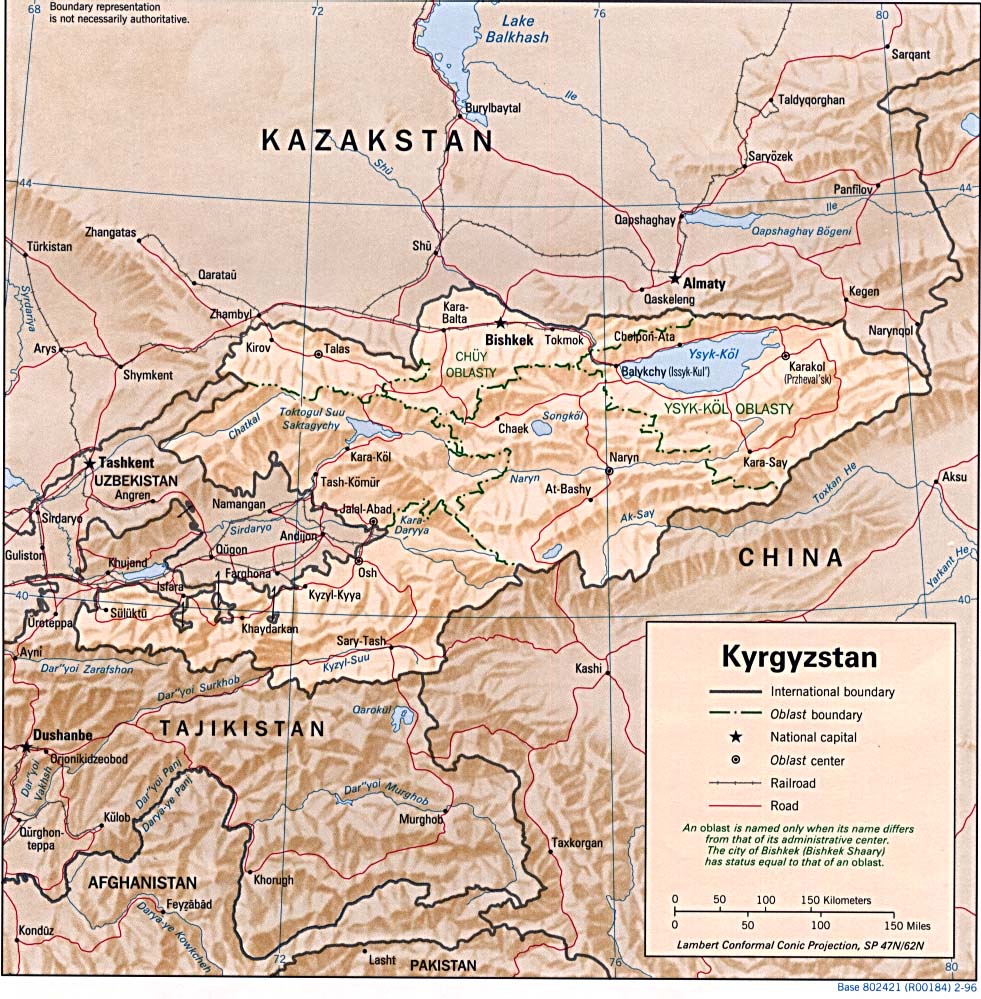 True - outside our capital, Bishkek. we do not have many high- class hotels
and restaurants, comfortable roads and cozy campsites. but they arc in
tile process of development, and we are confident that all ofthis will
soon come. We have a beautiful, mountainous country 94 %of our country
is mountainous, and the sheer untouched beauty of our mountains, mostly
free from ski lifts and funiculars, frequently used paths and observation
platforms, is majestic and intact. We have managed to preserve our natural
world. We like to think that tile air of our mountains tastes like the
purest spring water. We have unsullied rivers and lakes, remote and untouched
high mountain peaks; vast and primeval nature reigns and chasm the visitor,
bringing him closer to actual meaning of life and you can see, we are quite
a poetic people, too - but we hope to be In the central part of the
True - outside our capital, Bishkek. we do not have many high- class hotels
and restaurants, comfortable roads and cozy campsites. but they arc in
tile process of development, and we are confident that all ofthis will
soon come. We have a beautiful, mountainous country 94 %of our country
is mountainous, and the sheer untouched beauty of our mountains, mostly
free from ski lifts and funiculars, frequently used paths and observation
platforms, is majestic and intact. We have managed to preserve our natural
world. We like to think that tile air of our mountains tastes like the
purest spring water. We have unsullied rivers and lakes, remote and untouched
high mountain peaks; vast and primeval nature reigns and chasm the visitor,
bringing him closer to actual meaning of life and you can see, we are quite
a poetic people, too - but we hope to be In the central part of the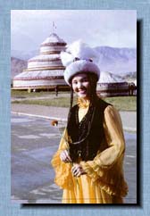 Chu valley, in the northern foothills ofthe Kyrgyz Range, at an altitude
of 750-900 meters, lies the largest city of the Republic - the capital,
Bishkek. The city was founded only in the second halfofthe the 19th century
It has a linear street structure, shaped by history, which some say contributes
to the better airing of the territories of the city by the winds that come
down from the nearby snow-capped mountains. Over the last decade the architectural
appearance of the city has changed considerably Beautiful indeed is the
Square of Ala-Too, and pleasant to the eye is the spacious and decorative
interior of Manas Airport (Bishkek airport). At the foot of the mountains,
new residential micro-districts lie. The city is blessed by numerous parks
and squares, and for the majority ofthe year in the streets are covered
by the green crowns of trees - one ofthe most distinctive features of our
pleasant capital. Boz-Peldek mountain (1,395 meters) is ( Is in the
southern outskirts of Bishkek and e easily accessible by city transport.
From its top you may gain a good view of the whole city.
Chu valley, in the northern foothills ofthe Kyrgyz Range, at an altitude
of 750-900 meters, lies the largest city of the Republic - the capital,
Bishkek. The city was founded only in the second halfofthe the 19th century
It has a linear street structure, shaped by history, which some say contributes
to the better airing of the territories of the city by the winds that come
down from the nearby snow-capped mountains. Over the last decade the architectural
appearance of the city has changed considerably Beautiful indeed is the
Square of Ala-Too, and pleasant to the eye is the spacious and decorative
interior of Manas Airport (Bishkek airport). At the foot of the mountains,
new residential micro-districts lie. The city is blessed by numerous parks
and squares, and for the majority ofthe year in the streets are covered
by the green crowns of trees - one ofthe most distinctive features of our
pleasant capital. Boz-Peldek mountain (1,395 meters) is ( Is in the
southern outskirts of Bishkek and e easily accessible by city transport.
From its top you may gain a good view of the whole city.
From the West to the East of Kyrgyzstan stretch the long chains orthe 88 mighty ranges of the grand mountain system of Ticn-Shall - which means the Celestial Mountains (or "sky-high" mountains). They certainly deserve the name. Most ofthem go high up beyond the snow line. and among them are the famed Victory Peak (7,439 m), Lenin Peak (7.134 m), the legendary white-and-pink marble pyramid of Khan Tengry (6,995 m) and many others, covered with snow caps and glaciers in summer and known by the name of Ala-Too which means 'Colorful Mountains'. On their giant shoulders they carry the marvelous land of Kyrgyaitan (we said we were poetic.) 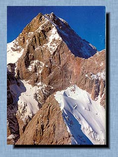 The
land-locked location of Kyrgyz- stan, its remote position from the oceans
of the world, its close proximity to the deserts of Central Asia, its high-altitude
elevation above sea level and the noticeable ruggedness of the terrain
- all this defines the unique variety and heterogeneity of our varied land.
Here you will find hot desert, green steppes, a deciduous and coniferous
wood zone, tundra, and quite a bit of local 'Arctics' as well. Unique in
its original and majestic beauty, with a new 'face' for each and every
period of the day and season of the year, nature is the main wealth and
resource of our country, - it will inspire you The
land-locked location of Kyrgyz- stan, its remote position from the oceans
of the world, its close proximity to the deserts of Central Asia, its high-altitude
elevation above sea level and the noticeable ruggedness of the terrain
- all this defines the unique variety and heterogeneity of our varied land.
Here you will find hot desert, green steppes, a deciduous and coniferous
wood zone, tundra, and quite a bit of local 'Arctics' as well. Unique in
its original and majestic beauty, with a new 'face' for each and every
period of the day and season of the year, nature is the main wealth and
resource of our country, - it will inspire you
with its emotional and physical impact. At an altitude of more than three kilometers above sea level up in the mountains may be found brownish-black accumulations called "murmye", tile medicinal aspects of which were first mentioned by the great Avicenna. Apart from the natural environment, the history of this land is fascinating, if probably unfamiliar to visitors. 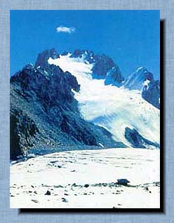 In
the territory of the Republic (roughly the same size as the UK) there are
more than five thousand historical and cultural monuments of past epochs
and long- vanished nations. Among them are cave dwellings of prehistoric
man, unique runic inscriptions on boulders, amazing cave drawings and stone
carvings, and remnants of ancient settlements and medieval fortresses which
are themselves astounding in their functional and architectural design.
Through the territory of K.yrgyzstan there passed the Great Silk Road,
along the route of which ancient settlements and caravan-sarais would cluster.
Their ruins still can be seen today The largest and most significant of
the archeological and architectural monuments in Kyrgyzstan are Suleiman
Mountain, the Architectural Complex of Uzgen, the Burana Tower, the Shah-Fasil
Mausoleum, and the Caravan-Sarai of Tash-Rabat. All of these are well worth
visiting, and your visit will provide you with enduring memories. In
the territory of the Republic (roughly the same size as the UK) there are
more than five thousand historical and cultural monuments of past epochs
and long- vanished nations. Among them are cave dwellings of prehistoric
man, unique runic inscriptions on boulders, amazing cave drawings and stone
carvings, and remnants of ancient settlements and medieval fortresses which
are themselves astounding in their functional and architectural design.
Through the territory of K.yrgyzstan there passed the Great Silk Road,
along the route of which ancient settlements and caravan-sarais would cluster.
Their ruins still can be seen today The largest and most significant of
the archeological and architectural monuments in Kyrgyzstan are Suleiman
Mountain, the Architectural Complex of Uzgen, the Burana Tower, the Shah-Fasil
Mausoleum, and the Caravan-Sarai of Tash-Rabat. All of these are well worth
visiting, and your visit will provide you with enduring memories.
"The Great Silk Road" is the popular name given to the system of caravan trade routes which lasted for approximately 15 centuries and linked the Easterly and Western civilizations between the Ancient and Middle Ages. The main route of the Road passed through China along the Gan-Su corridor then through the Tarirna basin, and the highlands of the Pamir and Tien-Shan ranges, into Central Asia, Afghanistan Iran, the Eastern shores of the Mediterranean, and still further on to major trading centers of the Near East, North Africa, and Europe. The Great Silk Road first functioned as a route from China to the capital of the Roman Empire in the 2nd century Be.  It was about seven thousand kilometers long. The most valuable commodity
imported from China was silk, which is an obvious explanation why this
entire transcontinental trade route was named The Silk Road. The Great
Silk Road is, in fact, a network of routes which played a highly significant
role in the lives of many people in Eurasia. It was an important artery
in the Ancient and Middle Ages, a source of merchandise and information,
and the starting point of many conflicts and wars. Along this route came
into existence, and then into decline, many nations and cultures, great
powers, trading centers, and capitals of many of the former empires of
the world. Trading centers and capitals of these empires sprang up, flourished
and gained fame, and then decayed and declined. The geographical location
ofKyrgyzstan predetermined its important position on The Great Silk Road.
In the 2nd century Be, with the Road coming into existence, nomerous and
systematic efforts were made to cross the Tien-Shan - Pamir Barrier. Some
even argue that this section ofthe Road operated much earlier, in the 4th
century Be. In any case, the territory and nations of the ancient Tien-Shan
were right in the middle of the process of formation of this vast economic
and cultural phenomenon.
It was about seven thousand kilometers long. The most valuable commodity
imported from China was silk, which is an obvious explanation why this
entire transcontinental trade route was named The Silk Road. The Great
Silk Road is, in fact, a network of routes which played a highly significant
role in the lives of many people in Eurasia. It was an important artery
in the Ancient and Middle Ages, a source of merchandise and information,
and the starting point of many conflicts and wars. Along this route came
into existence, and then into decline, many nations and cultures, great
powers, trading centers, and capitals of many of the former empires of
the world. Trading centers and capitals of these empires sprang up, flourished
and gained fame, and then decayed and declined. The geographical location
ofKyrgyzstan predetermined its important position on The Great Silk Road.
In the 2nd century Be, with the Road coming into existence, nomerous and
systematic efforts were made to cross the Tien-Shan - Pamir Barrier. Some
even argue that this section ofthe Road operated much earlier, in the 4th
century Be. In any case, the territory and nations of the ancient Tien-Shan
were right in the middle of the process of formation of this vast economic
and cultural phenomenon. 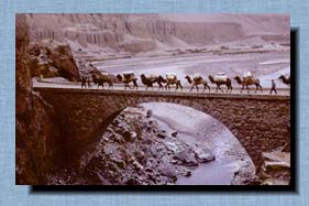 Many
of the caravan routes of the Great Silk Road changed their intermediate
destinations, observing only the maul directions from East to West and
back again. But in this region the routes stayed as they were for many
hundreds of years, because of the close proximity of the Tien-Shan, and
Pamir mountains with their specific geographical factors. From the very
beginning, three branches of The Great Silk Road ran through Kyrgyzstan.
The first, the Southern branch, ran from Termez via Samarkand to Dushanbe's
present location, along a tributary of Kyzyl-Su up to Alai and exited to
the area of modern Irkishtam, where it switched direction towards Kashgar.
The second, the Fergana branch, led from Salnarkand via Hodjent to Isfara,
Kokand and Osh. There are indications that the Taht-i-Suleiman otOsh was
the tower and the main signpost of the Silk Road which was described by
Ptolemeus. Osh was a major intermediate trading city from which caravans
proceeded further to Kashgar across the Torugart range. The third. Northern
branch came from Zamin Rabat to Benket (Tashkent), Isfidjab (Chirnkent),
Taraz (Jambul), Nuzket (Kara-Balta), and Balasugun (Burana). From there
caravans traveled along the Boom Canyon to get to the Issyk-Kul area and
further to China across the San-Tash range. Many
of the caravan routes of the Great Silk Road changed their intermediate
destinations, observing only the maul directions from East to West and
back again. But in this region the routes stayed as they were for many
hundreds of years, because of the close proximity of the Tien-Shan, and
Pamir mountains with their specific geographical factors. From the very
beginning, three branches of The Great Silk Road ran through Kyrgyzstan.
The first, the Southern branch, ran from Termez via Samarkand to Dushanbe's
present location, along a tributary of Kyzyl-Su up to Alai and exited to
the area of modern Irkishtam, where it switched direction towards Kashgar.
The second, the Fergana branch, led from Salnarkand via Hodjent to Isfara,
Kokand and Osh. There are indications that the Taht-i-Suleiman otOsh was
the tower and the main signpost of the Silk Road which was described by
Ptolemeus. Osh was a major intermediate trading city from which caravans
proceeded further to Kashgar across the Torugart range. The third. Northern
branch came from Zamin Rabat to Benket (Tashkent), Isfidjab (Chirnkent),
Taraz (Jambul), Nuzket (Kara-Balta), and Balasugun (Burana). From there
caravans traveled along the Boom Canyon to get to the Issyk-Kul area and
further to China across the San-Tash range. The
caravan traffic proceeded at a slow pace. A good day's journey covered
8 farsahs (50 km), a not so good one 4 farsahs (25 km). The composition
of the caravan trains varied. There are numerous records of some huge trains
containing up to 10.000 beasts of burden. All along the route. caravan-sarais
(meeting places) appeared at regular intervals. Torrential streams were
tamed with bridges. There was little caravan traffic from China to the
Mediterranean. Because the international route opened up access to new
places, settled crop production began, alongside nomadic livestock breeding.
This occurred in the valleys of Talas, Chu.lssyk-Kul and in Central Tien-Shan.
Thus Medieval Kyrgyzstan, its territory transsected by the three branches
of the Great Silk Road, came to be one of the cultural centers of the ancient
Turkic nations. It is not by chance that out of the whole of the huge Turkic
world, which stretched from Baikal to the Black Sea area and from the taiga
to the Great Wall of China, it was in Tien-Shan that the firstTurkic money
appeared, and J.Balasugun, the poet, created the Turkic poem of Kutagdu
Bilim. A prominent position on the Great Silk Road was maintained by Osh,
the main city in the south of modern Kyrgyzstan. For many thousands of
years, because of its unique location, it was a transit point on the Fergana
branch of the Silk Road. Local inhabitants provided services to travelers
and traders' caravans. Osh. as a convenient place to trade and exchange
goods, attracted traders, craftsmen, livestock breeders and crop producers.
The surroundings of the holy mountain of Suleiman with its mosques and
the tombs of the righteous, was a place where up to 10000 people might
convene at any one time. At present, there is still a Muslim pilgrimage
to the holy mountain. In the unique speleologic complex built inside the
mountain there is a history and land museum, with 13 exhibition halls.
The Suleiman Mountain also has observation platforms from which one can
enjoy the panoramic view of the city. Osh is considered to be one of the
most interesting arheological and historical monuments of past epochs and
- not by chance - the world community is soon going to celebrate the 3000th
annivesary of this unique settlement. The
caravan traffic proceeded at a slow pace. A good day's journey covered
8 farsahs (50 km), a not so good one 4 farsahs (25 km). The composition
of the caravan trains varied. There are numerous records of some huge trains
containing up to 10.000 beasts of burden. All along the route. caravan-sarais
(meeting places) appeared at regular intervals. Torrential streams were
tamed with bridges. There was little caravan traffic from China to the
Mediterranean. Because the international route opened up access to new
places, settled crop production began, alongside nomadic livestock breeding.
This occurred in the valleys of Talas, Chu.lssyk-Kul and in Central Tien-Shan.
Thus Medieval Kyrgyzstan, its territory transsected by the three branches
of the Great Silk Road, came to be one of the cultural centers of the ancient
Turkic nations. It is not by chance that out of the whole of the huge Turkic
world, which stretched from Baikal to the Black Sea area and from the taiga
to the Great Wall of China, it was in Tien-Shan that the firstTurkic money
appeared, and J.Balasugun, the poet, created the Turkic poem of Kutagdu
Bilim. A prominent position on the Great Silk Road was maintained by Osh,
the main city in the south of modern Kyrgyzstan. For many thousands of
years, because of its unique location, it was a transit point on the Fergana
branch of the Silk Road. Local inhabitants provided services to travelers
and traders' caravans. Osh. as a convenient place to trade and exchange
goods, attracted traders, craftsmen, livestock breeders and crop producers.
The surroundings of the holy mountain of Suleiman with its mosques and
the tombs of the righteous, was a place where up to 10000 people might
convene at any one time. At present, there is still a Muslim pilgrimage
to the holy mountain. In the unique speleologic complex built inside the
mountain there is a history and land museum, with 13 exhibition halls.
The Suleiman Mountain also has observation platforms from which one can
enjoy the panoramic view of the city. Osh is considered to be one of the
most interesting arheological and historical monuments of past epochs and
- not by chance - the world community is soon going to celebrate the 3000th
annivesary of this unique settlement.
Mountains are the symbol of the Republic, which is hardly surprising since they often begin at the very city boundaries. In the Kyrgyz Ala-Too range which encircles the Chu valley from the north, there are 480 glac- iers of various sizes, with a total length of near- ly 400 km. The largest are located in the cen- tral part of the range between the upper reach- es of the Ala-Archa and Alarnedin rivers. "The pearl ofTien-Shall" is the proud local name for Lake Issyk-Kul. The lake ranks second among the world's largest mountain lakes, after South America's Titikaka, and is the largest water reservoir in Central Asia to have no outlets, with a volume of 1,738 cubic kilometers. It is second largest after the Aral Sea in surface area (6,236 square kilometers) and Baikal in depth (668 meters); and almost certainly, it is one of the world's cleanest and most beautiful lakes. 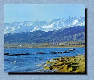 Lying
in a bowl of snowy mountains it is situ- ated at an altitude of 1,607 meters,
and stretches from East to West. At its widest point it is 60 km wide,
and its length is about 180 km. The length of the shore line of Issyk-
Kul is 688 km. In the south, it is rimmed by the slopes of the Terskei-Ala-Too
range ('Colorful mountains reverted from the sun') and in the North by
the Kungei-Ala-Too range ('Colorful mountains facing the sun'). The name
'Issyk-Kul' means 'Warm Lake' and the lake it self never freezes. Due to
the combination of mountain and maritime climates in the lake-front area,
the air in summer is never hot and stifling, while the nights are cool
and tranquil-The average monthly temperature in summer is 18 degrees C,
whereas in January it is rarely below minus 5 degrees. All this makes the
lake a large and superb resort area. In summer, the tempera ture of the
lake in shallow water is 25-28 degrees C, and in deep water - only 20 degrees.
The best time for lake-side recre ation is from June to mid-September Lying
in a bowl of snowy mountains it is situ- ated at an altitude of 1,607 meters,
and stretches from East to West. At its widest point it is 60 km wide,
and its length is about 180 km. The length of the shore line of Issyk-
Kul is 688 km. In the south, it is rimmed by the slopes of the Terskei-Ala-Too
range ('Colorful mountains reverted from the sun') and in the North by
the Kungei-Ala-Too range ('Colorful mountains facing the sun'). The name
'Issyk-Kul' means 'Warm Lake' and the lake it self never freezes. Due to
the combination of mountain and maritime climates in the lake-front area,
the air in summer is never hot and stifling, while the nights are cool
and tranquil-The average monthly temperature in summer is 18 degrees C,
whereas in January it is rarely below minus 5 degrees. All this makes the
lake a large and superb resort area. In summer, the tempera ture of the
lake in shallow water is 25-28 degrees C, and in deep water - only 20 degrees.
The best time for lake-side recre ation is from June to mid-September
Eighty small to medium-sized moun tain rivers, carrying the dissolved results of' erosion. flow down into tile lake, but none or them flows out of it. Tile lake's water evaporates, and tile salts stay, making tile water taste mildly salty and tile lake itself clearly reminiscent of a sea. Sailing, windsurfing, rowing, scuba diving, and fishing on tile quiet shores of Warm Lake may well be exactly the kind of recreation which will appeal to you. 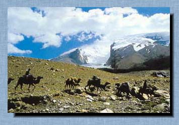 Tile Pearl of-Tiell-Sllan conceals many mysteries. Various nomadic tribal
cultures, arriving ill succession. have left artifacts of their long vanished
existence: Neanderthal camps, ancient burial hills, clusters of cave rock
drawings, mysterious stone dolls and the ruins of towns hidden beneath
tile lake's waters. For many miles, from the watershed of Terskei-Ala-Too
to the South and South- East, stretch "syrts", which are plateaus located
at an altitude of 3.200 to 3,700 meters ill the upper reaches of the Naryn
and Sary-Jaz rivers, intersected by the ranges of Sary-Jaz. Ak-Shyyrak,
lnylchek. Kalyndy, etc. These ranges, converging together in the eastern
part of tile area, form tile impressive mountain junction of Muzdag where
tile famous Victory Peak (7,439 meters) lies. Have you ever had tile opportunity
to travel in a relatively short period of time. through a sultry valley.
(lunching on deli- cious melons), walking along cool and pleasant mountain
canyons, (snacking on the fruit of berry bushes and nut trees), climbing
up to blossoming alpine meadows and, finally, touching the snow of the
high peaks? If not, then we welcome you to the South of the Republic. The
ridges of these mighty ranges are the natural boundaries of this land -
the Chatkal range in the North, the Fergana range in the East, the Turkestan,
Alai and Beyond-Alai ranges in the South. The Chatkal range, bordering
the Jalal-Abad Region area in the North-East. The highest point here is
Kara-Kuldija (4940 m.). The Turkestan range, enclosing the Fergana valley
in the far southwest of the Republic, soars to an altitude of 3800 to 4000
meters, with its highest point at Pyramid Peak (5509 m.).
Tile Pearl of-Tiell-Sllan conceals many mysteries. Various nomadic tribal
cultures, arriving ill succession. have left artifacts of their long vanished
existence: Neanderthal camps, ancient burial hills, clusters of cave rock
drawings, mysterious stone dolls and the ruins of towns hidden beneath
tile lake's waters. For many miles, from the watershed of Terskei-Ala-Too
to the South and South- East, stretch "syrts", which are plateaus located
at an altitude of 3.200 to 3,700 meters ill the upper reaches of the Naryn
and Sary-Jaz rivers, intersected by the ranges of Sary-Jaz. Ak-Shyyrak,
lnylchek. Kalyndy, etc. These ranges, converging together in the eastern
part of tile area, form tile impressive mountain junction of Muzdag where
tile famous Victory Peak (7,439 meters) lies. Have you ever had tile opportunity
to travel in a relatively short period of time. through a sultry valley.
(lunching on deli- cious melons), walking along cool and pleasant mountain
canyons, (snacking on the fruit of berry bushes and nut trees), climbing
up to blossoming alpine meadows and, finally, touching the snow of the
high peaks? If not, then we welcome you to the South of the Republic. The
ridges of these mighty ranges are the natural boundaries of this land -
the Chatkal range in the North, the Fergana range in the East, the Turkestan,
Alai and Beyond-Alai ranges in the South. The Chatkal range, bordering
the Jalal-Abad Region area in the North-East. The highest point here is
Kara-Kuldija (4940 m.). The Turkestan range, enclosing the Fergana valley
in the far southwest of the Republic, soars to an altitude of 3800 to 4000
meters, with its highest point at Pyramid Peak (5509 m.).  In the South, there are 240 mountain rivers, and all of them are connected
to the basin of the Syr-Darya river, expect for the Kysyl-Suu river which
flows past the Alai valley and into the basin of the Amu-Darya river.
Here one can find 50 thermal and mineral springs. In the vicinity ofthe
city of Jalal-Abad, in the low-mountain zone, multitudes of mineral springs
rise to the surface, forming the basis for a spa resorts. It is located
at an altitude of 975 meters on the slopes of Ayub-Too, in a large and
shadypark. Its springs are highly ranked alongside those of the most famous
resorts of the world. Many centuries ago the territory of Southern Kyrgyzstan
was part of the ancient powers of Davan, Kushan and the Karakhanides, which
comprised about one hundred towns erected in accordance with a remarkable
architectural culture. Many fortresses and settlements were scattered all
around the vast land. Llzgen was the capital of Karakhamdes, and the Great
Silk Road went via Osh. Arslanbob lies on the southwest slopes of the Fergana
range, 180 km from Osh. Groves or ancient fruit and nut woml land, many-millennia
old, are at an altitude of between 1,200 to 2.000 meters and occupy an
area of70,000 hectares. Tile prevail- ing species is walnut which grows
in abudance on the north facing slopes. Many the trees can be seen along
the river banks. Given good growing conditions, walnut trees with their
spherical crowns can reach 30 meters in height, and their trunks which
are covered with time-cracked bark, may be as large as two meters in diameter.
The fruit (or "meat'') of the walnut is not only tasty but is also of high
nutritional value. Apart from its fruit, walnut wood is a precious product,
being firm, resistant to rot and easily proecssable and polishable. In
the vicinities ofArslanbob there are two waterfalls that have been mentioned
in legends. The larger one is 6 km away from the near- est village and
is 80 meters high, the small one - which faces the sun and gives rise to
a rainbow- leaps out from a green wall at a height of 30 meters. The main
tourist attraction on the slopes of the Chatkal range is Sary-Chelek lake
and the surrounding forests and national parks. These serve as a unique
geo- botanical museum where plants typical for this area grow alongside
species characteris- tic of Siberia. Lake Sary-Chelek is located 1.873
meters above sea level in a unique mountainous valley filled with sky-blue
water: a glade stretching from the South-East to the North-West for almost
7 km. The width or the lake ranges from 350 meters ill the middle to 1,500
meters in its South- western part. Dozens of small burbling streams run
into the lake from the sur- rounding canyons.
In the South, there are 240 mountain rivers, and all of them are connected
to the basin of the Syr-Darya river, expect for the Kysyl-Suu river which
flows past the Alai valley and into the basin of the Amu-Darya river.
Here one can find 50 thermal and mineral springs. In the vicinity ofthe
city of Jalal-Abad, in the low-mountain zone, multitudes of mineral springs
rise to the surface, forming the basis for a spa resorts. It is located
at an altitude of 975 meters on the slopes of Ayub-Too, in a large and
shadypark. Its springs are highly ranked alongside those of the most famous
resorts of the world. Many centuries ago the territory of Southern Kyrgyzstan
was part of the ancient powers of Davan, Kushan and the Karakhanides, which
comprised about one hundred towns erected in accordance with a remarkable
architectural culture. Many fortresses and settlements were scattered all
around the vast land. Llzgen was the capital of Karakhamdes, and the Great
Silk Road went via Osh. Arslanbob lies on the southwest slopes of the Fergana
range, 180 km from Osh. Groves or ancient fruit and nut woml land, many-millennia
old, are at an altitude of between 1,200 to 2.000 meters and occupy an
area of70,000 hectares. Tile prevail- ing species is walnut which grows
in abudance on the north facing slopes. Many the trees can be seen along
the river banks. Given good growing conditions, walnut trees with their
spherical crowns can reach 30 meters in height, and their trunks which
are covered with time-cracked bark, may be as large as two meters in diameter.
The fruit (or "meat'') of the walnut is not only tasty but is also of high
nutritional value. Apart from its fruit, walnut wood is a precious product,
being firm, resistant to rot and easily proecssable and polishable. In
the vicinities ofArslanbob there are two waterfalls that have been mentioned
in legends. The larger one is 6 km away from the near- est village and
is 80 meters high, the small one - which faces the sun and gives rise to
a rainbow- leaps out from a green wall at a height of 30 meters. The main
tourist attraction on the slopes of the Chatkal range is Sary-Chelek lake
and the surrounding forests and national parks. These serve as a unique
geo- botanical museum where plants typical for this area grow alongside
species characteris- tic of Siberia. Lake Sary-Chelek is located 1.873
meters above sea level in a unique mountainous valley filled with sky-blue
water: a glade stretching from the South-East to the North-West for almost
7 km. The width or the lake ranges from 350 meters ill the middle to 1,500
meters in its South- western part. Dozens of small burbling streams run
into the lake from the sur- rounding canyons.  Many
start their jour- ney as bubbling mineral springs. Tile lake is surrounded
by a necklace of sparkling snowcapped mountain peaks. This unique nature
reserve is home to a rich variety of fauna: tile indigenous inhabi- tants
of tills place arc wild boars, bears. foxes, wolves, and hares. Some time
ago zubrs from tile Pryoksky nature reserve were placed there as an experiment.
These rarest of animals have now made their home in tile region. The shores
of Sary-Cllelck are unusually picturesque. Almost vertical. they go down
into the dark water to a depth of 234 meters. The northern slopes are draped
with slender fir and silver fir trees. Tile crowns of the trees are some-
times so dense that tile sky cannot be seen through the leaves and branches.
The natural environment of Alai is quite different. Long canyons lead into
mountain ranges above 4,000 meters high and then the dramatic panorama
of the Pamir range appears. Wonderful narrow canyons encircle beautiful
snow-capped and needle-sharp peaks; a combination of limestone and colored
marble. From tile head of the river opens up a view of many spike- and
tower-shaped peaks: most of them with no conventional names. These picturesque
canyons are rich with juniper woods, which provide wonderfully clear and
curative air to the valleys, for tile enjoyment of human beings. You can
breath such air only in the high mountains of Kyrgyzstan. Many
start their jour- ney as bubbling mineral springs. Tile lake is surrounded
by a necklace of sparkling snowcapped mountain peaks. This unique nature
reserve is home to a rich variety of fauna: tile indigenous inhabi- tants
of tills place arc wild boars, bears. foxes, wolves, and hares. Some time
ago zubrs from tile Pryoksky nature reserve were placed there as an experiment.
These rarest of animals have now made their home in tile region. The shores
of Sary-Cllelck are unusually picturesque. Almost vertical. they go down
into the dark water to a depth of 234 meters. The northern slopes are draped
with slender fir and silver fir trees. Tile crowns of the trees are some-
times so dense that tile sky cannot be seen through the leaves and branches.
The natural environment of Alai is quite different. Long canyons lead into
mountain ranges above 4,000 meters high and then the dramatic panorama
of the Pamir range appears. Wonderful narrow canyons encircle beautiful
snow-capped and needle-sharp peaks; a combination of limestone and colored
marble. From tile head of the river opens up a view of many spike- and
tower-shaped peaks: most of them with no conventional names. These picturesque
canyons are rich with juniper woods, which provide wonderfully clear and
curative air to the valleys, for tile enjoyment of human beings. You can
breath such air only in the high mountains of Kyrgyzstan.
The largest river in Kyrgyzstan is tile Naryn river, which is Mongolian for 'Sunny'. Clearly, this is because the source of the river is the mountain complex ofAk-Shyirak which rises high up towards the sun. The Naryn is 600 km long. For 500 km of its length, it flows through Kyrgyzstan. Winter here can last from 6 to 8 months. In the valleys ofAlai and Arpin, as well as the upper reaches of the Nairn. and also in the bowl ofSon-K-el, there are no frost-free periods at all. Temperatures here can fall to minus 40-50 degrees. 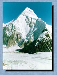 The highlands are particularly attractive in spring and early summer, when
an abundance of flowers, and comfortable temperatures, create good conditions
for traveling. The fauna in this land of high mountains is rich and varied.
In the river canyons roam roe-deer, martens, lynxes. wild boars, and porcupines.
In the coniferous woods you may meet a brown bear. Flocks of wild goats
and some Marco Polo sheep inhabit the upper levels of the mountains. Here
also, the rare snow leopard stalks his prey. Notwithstanding the austere
climate and the mountainous landscape, this cloudy realm has been populated
since olden times. Traces of primeval man's camps and ancient settlements
arc found all through the territory. Stone dolls, cave paintings, and burial
tomb sites are silent witnesses to events which occurred many centuries
ago. Along the caravan routes from the Fergana valley through the Tien-
Shan, historic and cultural monuments of the medieval period are also found
quite widely: fortresses that were first founded as nomadic camps. Khanate
headquarters, and military bases and factories. The "top floor" of this
Country of the Celestial Mountains rises up beyond seven thousand meters.
It can be pictured as two towers of an utterly complex architectural design
one of which is located in the extreme North-East of the country, right
in the heart of Tien-Shan, and the other in the extreme South-West where
the Pamir thrusts up its mighty ranges. This zone accessible only to experienced
back-packers and mountaineers. For those who prefer living on the edge
and who love difficult challenges, here - on the upper floors of the area
- the choices are virtually inexhaustible. One of the largest
glaciers in the world - the lnylchek glacier - is located here. It is about
60 km long, and up to 450 meters wide. The ice covers an area of 583 square
meters. The glacier is more than 1,8 km deep and the climatic conditions
in different sections are quite varied. At the end of the glacier, the
surface is covered with a veil of stones and earth, and here Eidelweiss
and Richteria Chamomile grow. Of considerable interest is the glacier lake
of Merzbaher named after the outstanding German traveler who discovered
it in 1903. It is four km long, one km wide, and from 40 to 80 meters deep.
The lake spreads out in the upper areas of North lnylchck. Here one can
observe a rare view characteristic of the Arctic regions of the World -
huge chunks of ice that split from the glacier and form the most amazing
iceberg shapes.
The highlands are particularly attractive in spring and early summer, when
an abundance of flowers, and comfortable temperatures, create good conditions
for traveling. The fauna in this land of high mountains is rich and varied.
In the river canyons roam roe-deer, martens, lynxes. wild boars, and porcupines.
In the coniferous woods you may meet a brown bear. Flocks of wild goats
and some Marco Polo sheep inhabit the upper levels of the mountains. Here
also, the rare snow leopard stalks his prey. Notwithstanding the austere
climate and the mountainous landscape, this cloudy realm has been populated
since olden times. Traces of primeval man's camps and ancient settlements
arc found all through the territory. Stone dolls, cave paintings, and burial
tomb sites are silent witnesses to events which occurred many centuries
ago. Along the caravan routes from the Fergana valley through the Tien-
Shan, historic and cultural monuments of the medieval period are also found
quite widely: fortresses that were first founded as nomadic camps. Khanate
headquarters, and military bases and factories. The "top floor" of this
Country of the Celestial Mountains rises up beyond seven thousand meters.
It can be pictured as two towers of an utterly complex architectural design
one of which is located in the extreme North-East of the country, right
in the heart of Tien-Shan, and the other in the extreme South-West where
the Pamir thrusts up its mighty ranges. This zone accessible only to experienced
back-packers and mountaineers. For those who prefer living on the edge
and who love difficult challenges, here - on the upper floors of the area
- the choices are virtually inexhaustible. One of the largest
glaciers in the world - the lnylchek glacier - is located here. It is about
60 km long, and up to 450 meters wide. The ice covers an area of 583 square
meters. The glacier is more than 1,8 km deep and the climatic conditions
in different sections are quite varied. At the end of the glacier, the
surface is covered with a veil of stones and earth, and here Eidelweiss
and Richteria Chamomile grow. Of considerable interest is the glacier lake
of Merzbaher named after the outstanding German traveler who discovered
it in 1903. It is four km long, one km wide, and from 40 to 80 meters deep.
The lake spreads out in the upper areas of North lnylchck. Here one can
observe a rare view characteristic of the Arctic regions of the World -
huge chunks of ice that split from the glacier and form the most amazing
iceberg shapes.
Victory Peak is a world-renowned peak which has its own considerable history It rises three and a half kilometers above the glaciers oflnylchek. 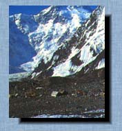 The point ofthe peak is a razor- sharp edge of rock and ice, 2 km long,
with eaves of snow hanging all around it. More than 200 climbers have reached
this point. Khan-Tengri Peak is a snowy tapering pyramid of white and pink
marble. Kllan- Tengri Peak is especially attractive in the twilight - a
glowing ruby against the darkening blue sky The Chinese call this peak,
one of the world's most remarkable and beautiful mountains, the' Ruler
of Ghosts' and 'Master of the Sky'. Local dwellers call it Kail-Too (Blood
Mountain). The peak looks quite imposing even to the eye of seasoned mountaineers.
The enormous ice and snow masses are menacingly suspended over 2-km high
precipices. The peak was firet conquered in 1931 by three mountaineers,
led by M. Pogrebetzki. On the "top floor" of the Republic's Pamir highlands
is Lenin's Peak (7.134 m) in the middle of the "Beyond-Alar' range. The
huge tip of this peak is a pyramid of irregular shape. On the side that
faces the Alai valley the peak is wholly clad in an armour of ice and the
mountain sides are wrapped in snow Next to it are located lower, but similarly
shaped peaks. From this range of peaks, where "only the sky is higher",
there opens out a view of the remarkable panorama of this mountainous land,
where tile green alpine valleys arc pierced with yellow-red lines, tracing
the course of rivers. Glaciers, full of crevices, terminate in gigantic
icefalls.
The point ofthe peak is a razor- sharp edge of rock and ice, 2 km long,
with eaves of snow hanging all around it. More than 200 climbers have reached
this point. Khan-Tengri Peak is a snowy tapering pyramid of white and pink
marble. Kllan- Tengri Peak is especially attractive in the twilight - a
glowing ruby against the darkening blue sky The Chinese call this peak,
one of the world's most remarkable and beautiful mountains, the' Ruler
of Ghosts' and 'Master of the Sky'. Local dwellers call it Kail-Too (Blood
Mountain). The peak looks quite imposing even to the eye of seasoned mountaineers.
The enormous ice and snow masses are menacingly suspended over 2-km high
precipices. The peak was firet conquered in 1931 by three mountaineers,
led by M. Pogrebetzki. On the "top floor" of the Republic's Pamir highlands
is Lenin's Peak (7.134 m) in the middle of the "Beyond-Alar' range. The
huge tip of this peak is a pyramid of irregular shape. On the side that
faces the Alai valley the peak is wholly clad in an armour of ice and the
mountain sides are wrapped in snow Next to it are located lower, but similarly
shaped peaks. From this range of peaks, where "only the sky is higher",
there opens out a view of the remarkable panorama of this mountainous land,
where tile green alpine valleys arc pierced with yellow-red lines, tracing
the course of rivers. Glaciers, full of crevices, terminate in gigantic
icefalls.
Kyrgyzstan is also rich in caves. These are are scattered all over the vast territory of the Republic. fn the South, close to the village of Aravan which lies next to the Uzbekistan border, one can find several dozen caves in limestone hills, which are part of the Alai system. 'This tiny land of caves is conditionally called Chil-Ustun which is Tadjik for "40 columns", since the caves are full of column-shaped stalactites. ' And, just like any other country, the land of ' Chil-Ustun has it's own distinctly defined physical boundaries. It's area is relatively small - only about 200 square km. located in , the foothill flatlands of the Ak-Bura and Aravan river basins. The features of Chil- Ustun do not just show us a geological history they offer a chapter in the great book of life, without which it impossible to conceive of this land's past, present, and future. 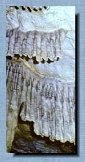 This
is a special world, all on its own. Here in February on the sun-lit slopes
newly born bristles of grass are flamboyantly green. Jn March, the almond
groves start out in colours of sparkling purple, then burst out into flames
of red and yellow tulips. In the land of Chil-Ustun night is eternal and
so, here, even time seems to pass at a different rate. Light up a torch
and you will see magic castles. Hold your breath and you can feel the ultimate
silence. You will hear drops of moisture seeming to cry out every time
they loose their grasp on the invisible ceiling. And you will hear your
own heart pumping violently a captive in a cave of its own. In the land
of Chil-Ustun there are many caves. And though all of them seem alike,
each is actually unique. There are several dozen large caves that are
more than 100 meters long. Still, the main cave - the pride and beauty
of the country - is Chil-Ustun. This differs from the other caves because
of the unsurpassed beauty of its underground kingdom. The caves entrance
is a vertical southern slope of the mountain that shares its name with
the cave. The cave is of horizontal structure and consists of three spacious
halls connected to each other by narrow and winding corridors. The "Gothic"
cupolas of the halls are propped up by many sparkling light pink columns,
which produce an impression of having been made by a skillful craftsman.
From the ceiling there hang knit-work chandeliers of aragonite, and on
the walls are patterns of tinted silent, especially when you lightly touch
them. This may produce a tender and subtle music which is very clear and
bright in pitch and tone. In the first hall of the cave, both on the walls
and cupolas, are numerous ancient drawings and inscriptions in various
languages, including Sanskrit. This cave is 380 meters long. In addition
to the cave ofdlil-Ustun, on the steep slopes of the mountains are the
equally interesting and easily accessible caves ofSasyk-Llnkur (about 140
m deep), Suvli- Karnar (120 m), Chil-Mairam (130 m), Teshik-Tash (180 m),
Serpent (180 m), and Bosh-Unkur(IOOm). To the South of Mount Chil-Ustun
is the Dangi Canyon, which is dissected by the fierce torrents of the Aravan
River. Its banks of steep red and gray walls descend into the pewter-opaque
glitter of the cataract. Far above, a broken blue strip of sky can be seen.
Ibex, racer stallions and ritual symbols are carved on the vertical walls.
In the canyon area is a series of most interesting caves, easily accessible
to tourists. The cave Adjidar-Unkur is on the southern vertical slope of
the Tuya-Muyun mountain. Tills legendary cave lias a large tunnel which
goes more than 120 meters into the limestone mountain. Large colonies of
bats reside here, and you may hear their twittering and movement long before
you have approached their habitat. Two hundred meters from Adjydar- Unkur.
in the same southern slope, is a big barite slope. It is a sack-like cavity
60 meters deep which descends in impressive onyx steps. The cave has two
entrances: a natural entrance, in the form of a karst well 20 meters deep,
and an artificial one, a drift, which provides easy access to the lower,
more beautiful section of the cave. This
is a special world, all on its own. Here in February on the sun-lit slopes
newly born bristles of grass are flamboyantly green. Jn March, the almond
groves start out in colours of sparkling purple, then burst out into flames
of red and yellow tulips. In the land of Chil-Ustun night is eternal and
so, here, even time seems to pass at a different rate. Light up a torch
and you will see magic castles. Hold your breath and you can feel the ultimate
silence. You will hear drops of moisture seeming to cry out every time
they loose their grasp on the invisible ceiling. And you will hear your
own heart pumping violently a captive in a cave of its own. In the land
of Chil-Ustun there are many caves. And though all of them seem alike,
each is actually unique. There are several dozen large caves that are
more than 100 meters long. Still, the main cave - the pride and beauty
of the country - is Chil-Ustun. This differs from the other caves because
of the unsurpassed beauty of its underground kingdom. The caves entrance
is a vertical southern slope of the mountain that shares its name with
the cave. The cave is of horizontal structure and consists of three spacious
halls connected to each other by narrow and winding corridors. The "Gothic"
cupolas of the halls are propped up by many sparkling light pink columns,
which produce an impression of having been made by a skillful craftsman.
From the ceiling there hang knit-work chandeliers of aragonite, and on
the walls are patterns of tinted silent, especially when you lightly touch
them. This may produce a tender and subtle music which is very clear and
bright in pitch and tone. In the first hall of the cave, both on the walls
and cupolas, are numerous ancient drawings and inscriptions in various
languages, including Sanskrit. This cave is 380 meters long. In addition
to the cave ofdlil-Ustun, on the steep slopes of the mountains are the
equally interesting and easily accessible caves ofSasyk-Llnkur (about 140
m deep), Suvli- Karnar (120 m), Chil-Mairam (130 m), Teshik-Tash (180 m),
Serpent (180 m), and Bosh-Unkur(IOOm). To the South of Mount Chil-Ustun
is the Dangi Canyon, which is dissected by the fierce torrents of the Aravan
River. Its banks of steep red and gray walls descend into the pewter-opaque
glitter of the cataract. Far above, a broken blue strip of sky can be seen.
Ibex, racer stallions and ritual symbols are carved on the vertical walls.
In the canyon area is a series of most interesting caves, easily accessible
to tourists. The cave Adjidar-Unkur is on the southern vertical slope of
the Tuya-Muyun mountain. Tills legendary cave lias a large tunnel which
goes more than 120 meters into the limestone mountain. Large colonies of
bats reside here, and you may hear their twittering and movement long before
you have approached their habitat. Two hundred meters from Adjydar- Unkur.
in the same southern slope, is a big barite slope. It is a sack-like cavity
60 meters deep which descends in impressive onyx steps. The cave has two
entrances: a natural entrance, in the form of a karst well 20 meters deep,
and an artificial one, a drift, which provides easy access to the lower,
more beautiful section of the cave.
The cave of Fersman consists of natural and man-made passages of various lengths. It is one of the deepest caves in the Republic. Its natural tunnel winds 240 meters down into the rock, to rich a thermal lake. The Surprise cave, which is also highly interesting, is on the right side of the canyon. A small round opening in the wall of the canyon leads to a picturesque underground gallery decorated with crystals and stalaktite shapes. This cave is 450 meters long. The main cave, Victorious, is somewhat farther to the East along the northern slope of the Hoschan mountain. Barely visible, the crevice at the watershed of the range leads to a white maze of underground passages and cavities worked through by the rising floes of thermal water. This cave is 12000 meters long. Several dozen kilometers farther to the South-East is a place of interest directly related to the world of eternal darkness, a unique creation of nature, namely Abshir waterfall. Out of a round opening about 2 meters in diameter, from the vertical 100 meter-long wall, sparkling water noisily gushes, and myriads of tiny water particles are suspended in the air as a mist. Last in the speleological tour program of Kyrghizstan comes the cave of Kan-I-Gut, which is in the extreme South-West of the country. This is a huge karst cave with an architectural design of many intermingled man-made labyrinths which resulted from silver extraction a century ago. |