|
|
Article
[Home][Article][Programs] [Prices for 1999] [Kirghizstan] [Central Asia][Photogallery] |
|
|
Article
[Home][Article][Programs] [Prices for 1999] [Kirghizstan] [Central Asia][Photogallery] |
| Author: Vladimir Komissarov
Federation of Alpinism and Rock Climbing Kyrgyz Republic, President Association of the Central Asia Touroperators, President Contents:
MOUNTAINEERING
POSSIBILITY OF KYRGYZSTAN
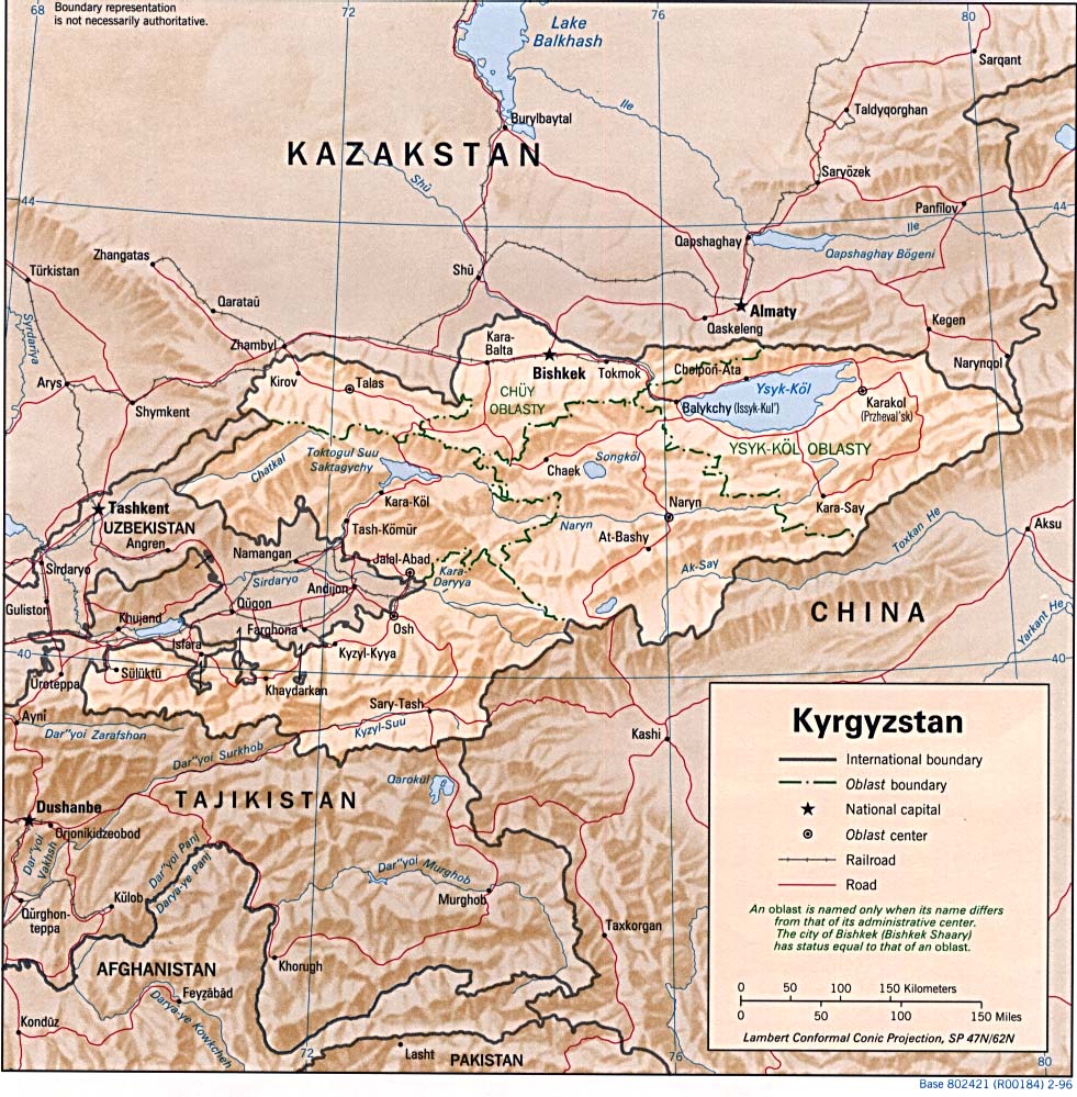
Kyrgyzstan is a new state, which got its independence in 1991. It was formed when the former USSR was disintegrated. Kyrgyzstan is situated in the Central Asia and borders Kazakhstan, Uzbekistan, Tadjikistan, and China. It covers about 200 square km, 85 percent of its area consists of mountains. They are the parts of two large mountain systems - the Tien-Shan and Pamirs. Average altitude of the Kyrgyzstan is 2500 m. Three summits of Kyrgyzstan tower higher than 7000 m. They are the peaks Pobeda (7439 m) and Khan-Tengri (6995 m) in the Tien-Shan and Lenin peak (7134 m) in the Pamir. The Tien-Shan is one of the largest mountain systems over Asia. It ex-tends about 2000 km in the latitudinal direction and is 400 km in width. About 2/3 mountains of the Tien-Shan is in Kyrgyzstan. The ranges of the Tien-Shan are made of sedimentary, metamorphic, and igneous rocks. The Tien-Shan falls into Northern, Western, Central, Inner, and Eastern Tien-Shan according to its orographic structure. The most of the ranges have typical mountain-glacier "alpine" relief. The ancient highly elevated flat surfaces like those in the Tibets, are, for example, on the southern slope of the Terskei Ala-Too or in the Inner Tien-Shan, where they are on the altitude of 4-5 thousand meters. The climate of the Tien-Shan is sharply continental, i.e., hot summer
on foothills and in valleys and cool and cold in the Alpine zone. Severe
for these latitude winter, rather strong temperature fluctuations within
a day and a year, cloudless and considerable dryness are characteristic
features of this area. Plenty of solar light. Average annual duration of
solar radi-ance amounts to from 2500 to 2700 hours. The highest possible
The relief, climatic peculiarities, snow lines, flora and fauna of the indi-vidual regions vary greatly. The Kyrgyz Republic covers only the most northern part of the Pamirs -- the northern slopes of the Zaalaiskii Ridge and Northern part of the Pamirs-Alai -- the mountains which separate the Tien-Shan and the Pamirs and which include Turkestan and Alai Ridges. The climate of the Pamirs is sharply continental, which is like in the Tien-Shan but differs from the latter by a comparatively stable weather, less humidity and more solar days. The densest cloudiness is in March and April like in the Tien-Shan and less cloudy sky is in August and September. The peculiarities of the climate will be given in more detail in describing the individual areas. One can single out eight areas that are of interest for alpinists. Five
of them are in the Tien-Shan and three in the Pamirs.
The Tien-Shan:
The Pamir:
SHORT DESCRIPTION OF THE ALPINE ZONES The Central Tien-Shan includes two areas: Northern and Southern Engilchek Glaciers and Kaindy Glacier. The Area of Northern & Southern EngiIchek Glaciers. The area is located in the most remote eastern part of Kyrgyzstan, at the borders of China and Kazakhstan including the eastern parts of the such ridges as Kok-Shaal-Too, Engilchek-Too, Sarydjaz as well as Tengri-Tag and Meriodinal Ridges. In this area there is one of the largest glaciers of the world -- Southern Engilchek Glacier the length of which stretches 62 km, the width amounts to 3.5 km, and the depth of ice reaches 200 m. There are two summits higher than 7000 m. They are the peaks of Po-beda and Khan-Tengri. There are 23 summits higher than 6000 m and about 80 summits 5000-6000 m in hight. Among them there are 3 sum-mits higher than 6000 m and 14 summits 5000-6000 m in hight are vir-gin. About 70 routes have been travelled. The most popular summits are the peaks of Khan-Tengri and Pobeda that are ascended along the 21 and 8 routes, respectively. The area of Southern Engilchek Glacier is the most severe one in the
Tien-Shan. It is usual thing in summer when the sun shines in the morn-ing
and close to the noon the sky starts to cover with clouds and it snows
in the afternoon. Sometimes the weather worsens for several days
and it is snowing for two or three days without ceasing. The most
stable weather sets in after August 5 and lasts by the middle of September,
but in September it becomes much colder than in August. The mean
tem-perature is 50, 70, and 30 C in July, August, and September, respec-tively.
The routes are combined, snow, and snow-ice. The slopes and summits
of the mountains are covered, as a rule, with snow and ice. In addition
to the technical difficulties, which are available on routes, the alpinists
may be caught by such danger as weather, which can worsen unexpectedly
and last several days and make the way you travelled be avalanche one as
well as cracks in the glaciers that are very insidious in this region.
Commonly one or two days are needed to have the snow be consolidated.
The Area of Kaindy Glacier. The area of Kaindy Glacier is situated in the vicinity of South Engilchek Glacier south-west from the latter. It includes the glaciers of Kaindy and Terekty. Weather conditions are similar to those of Southern Engilchek Glacier. This area is visited not so frequently as the latter and is characterized by summits 6073 m in hight. There are plenty of virgin summits there. The routes are combined, ice-snow , and snow; overfalls are up to 1000-1500 m. The first alpinist expeditions visited this place in 1995 and made their first ascents to seven summits of the area. The areas can be reached both by helicopter and by car with the help of porters. You may reach Engilchek settlement by car along 150-km asphalted road from Karakol, further about 30 km along a bad mountain road that may be got over only by a high-cross-country-capability car. It takes two days of going on foot up to the upper reaches of Engilchek Glacier starting from the terminal of the road. No porters, you should take them with yourself from Karakol. The Terskey Ala-Too is a range which stretches 300 km in the latitudinal
direction along the southern cost of the Issyk-Kul starting from its west-ern
extremity as far as the borders with China. Its northern slopes
of the central parts including such gorges as Dzhuuku , Kichi-Kyzylsuu,
Chon- Kyzylsuu, Dhzety-Oguz, Karakol, and Ak-suu are of interest for moun-taineers.
Among them the most popular are Dhzety-Oguz and Karakol in which the highest
summits of Terskey Ala-Too -- Dhzigit (5170 m), Karakolskii (5281 m), and
Oguz-Bashi (5158 m) and the highest walls are located. About 200
routes from the simplest to the most difficult ones have been travelled
here. The routes are various rather rock or combined than ice and
snow or snow. The difference of altitude are up to 1500 m.
The climate is considerably milder here than that in the Cen-tral Tien-Shan
due to the lower absolute altitudes and the neighbourhood of The Issyk-Kul.
Plenty of precipitation, it amounts to 1600 mm p/a. The largest portion
of precipitation falls to the beginning of summer. July and
August are characterized by frequent snowfalls and thunder-storms.
The most stable weather is in September, but in mountains it becomes much
colder than in valley. One can reach this area by car
from Karakol. The road extends 80 km through Dhzety-Oguz Gorge from Karakol,
further one-day going on foot as far as the regions for ascents.
Horses and porters are available. Horses may be found on place whereas
porters should be taken from Karakol. The distance be-tween Karakol
town and the end of the road in the Karakol Gorge is 12 km. The subsequent
road is washed away and going on foot is the only way of moving.
Horses and porters are available. It takes about one or two days
of going on foot from the terminal of road and the regions for ascents.
Other gorges of the Terskey Ala-Too are visited more rarily than Karakol
and Dhzety-Oguz, they provide mountaineers with ample opportunities for
making first ascents.
3. Kyrgyz Range ( of Ala-Archa and Alamedin Gorges). The area is situated in 40-km distance southwards from Bishkek, the capital of the Kyrgyz Republic . The summits lift up to the altitude of 4895 m (the highest point of the range is Semenov-Tien-Shanskii Peak). Routes are rock, combined, seldom ice and snow-ice. The rocks consist of tough granite and granodiorite. The difference of altitude is till 1100 m. The amount of precipitation attains 690 mm p/a. The least amount of precipitation falls in August and September while the largest one in May and June. The mean temperature is 120, - 7.50, and +30 C in sum-mer, winter, and autumn and spring, respectively. In the Kyrghyz Range the most popular is the area of Ak-Sai Glacier which is situated in Ala-Archa Gorge. About 150 routes from the sim-plest to the most complicated walls lifting up to 1100 m have been trav-elled there. There are four mountain huts there, three of which are small (roughly 4X4 m) and one hut made of stone and more comfortable ac-comodates up to 20 persons. It takes three hours of going on foot from the terminal of the road in Ala-Archa Gorge to the stop Ak-Sai. It takes 45 minutes of riding by car from Bishkek to the terminal of the road in the gorge. Other gorges of Ala-Archa -- Adygene, Topkaragai, Tuyuk, and Golu-bina -- are visited much seldom and have no such unique opportunities for ascents. The difference of altitude attains 600 m and the routes are, as a rule, simple and of average class of difficulty, but give much more opportunities for passing new routes. Alamedin. The area of Salyk Glacier is the most popular one. Similar to Ala-Archa area Aksai gives perfect opportunities for ascents and has walls lifting 1000 m. About 30 routes including the simplest and most difficult ones have been passed here. In addition, there are opportunities for making new routes there. The other glaciers of Alamedin such as Altyn-Tor and Tuyuk-Tor are less popular. The difference of altitude attains 500 m, the routes are easy or of average class of difficulty, there are excellent opportunities for passing new routes. The approaches to the place of ascent from the terminal of road in Alamedin are more dis-tant than that of in Ala-Archa. The way to Salyk takes 5 hours whereas to Altyn-Tor and Tuyuk-Tor 6 hours. The Western Kokshaal-Too is located in the south from the Issyk-Kul, on the border of China. Thare are the summits up to 5982 m (Dankov Peak), 17 summits rises above 5000 m and about 60 are of 4000 - 5000 m in high. The most of them, including 11 which are higher than 5000 m, are virgin. The difference between the foothills and the highest points reaches 1800 m and the walls are as high as 1200 m. The routes are rock, combined or snow-ice. The rocks are composed with red or grey granite and offers the perfect opportunities for climbing. The climate is very severe, and even in summer the temperature rises above zero very rare The most stable weather is within July and September. The average temperature is +40 C in July, +60 C in August, and +20 C in September. The annual amount of precipitation is 420 mm p/a. The area is rather distant and rarely visited. The approaches are short, 1-3 hour way on foot from the road to the routes. It is possible to reach East part ofthis place by a high-cross-road capability car along the 180-km road going from the southern cost of the Issyk-Kul over Barskaun and West part of the area by some mountain road, along 180 km road, going from Naryn town through Akmuz village. Akshiirak & Kuilu Ranges are located southwards from the eastern ex-tremity of the Issyk-Kul, in the half way from the lake cost to the Chi-nese border. Two rather independent areas in the vicinity to each other can be singled out. They are Akshiirak Ridge and in the east from it Kuilu Ridge. The climate is similar to that of the Central Tien-Shan but a bit milder. The annual amount of precipitation makes up 694 mm, the largest portion of it falls in summer months and the least one in winter. Annual temperature is 160 C in winter, -70 C in spring and autumn, +20 C in June, +40 C in July and August, and +0.50 C in September. The Akshiirak Ridge. The summits reaches 5126 m. There are abun-dance of ice patches and the glacier flows frequently from the passes and summits. The difference of altitude is up to 700 m and in its eastern part in the vicinity of the 5126-m Peak it lifts up to 1000 m. Plenty of ice patches and excellent conditions are for ski mountaineering the year round. Only in the second part of August and September the glaciers become free from snow. The routes are combined with large ice-snow sections and ice-snow or snow patches. There are no high vertical walls there. Various options of routes: simple, mean and, only in the northern and southern slopes of 5126-m Peak, complicated. There have been no alpinist expeditions here yet, the perfect chance for mountaineers to pio-neer and explore new routes. It is possible to reach this place by a high-cross-road-capability car starting from the southern cost of the Issyk-Kul over Barskun along 100-150-km mountain road. The approaches to the place of climbing takes 1-2 days. Kuilu Ridge. The ridge is situated to East from Akshiirak Ridge. Alti-tudes are here till 5281 m. Relief is more high them in Akshiirak Ridge. Routes here are combined or rocks. Only a few expedition have been here. It was climbed highest peak - Komstitution Peak and some peaks around. Plenty peaks till 5200 m from very simple routes to very difficult are virgin. Exess in this area possible by car from East along Koilu Gorge, along Uchkul Gorge or along Taldysuu River and from West through Sarychat Valley. For this area don't need special permits. 6. Perspective areas of the Tien-Shan for arrangement expedition in virgin areas are Borkoldoi, Atbashinskii, Djetymtoo Ranges and Djangart area of central part of the Kokshaaltoo Range. 7. Zaalaiskii Range. The most popular is the Achiktash Gorge. It is the most famous alpinist region all over the world. The easiest summit higher than 7000 m - 7134-m Lenin Peak - is here. The area is located on the northern slopes of the Zaalaiskii Ridge on the border of Tadjiki-stan. The plenty of ice patches, the slopes and summits are covered with ice and snow. The difference of altitude is up to 3000 m. The routes are technically not difficult mainly snow and snow-ice. They offer the mag-nificent opportunity to climb up such an altitude even with simple techni-cal training. The climate is much milder than that in the Tien-Shan. Av-erage temperature is 100 C in July-August. The largest portion of pre-cipitation falls in the period from April till the beginning of June and the smallest in August - September. To reach the base camp is possible with the help of a car along the 220-km mountain road over the 3165-m Taldyk Pass starting from Osh Town. In addition to Achiktash moun-taineers can climb Lenin Peak starting from the neighbouring Kamansu Gorge over the Razdelnaya Summit. Whereas in summer Achiktash teems with expeditions from all over the world, the latter route is rarely explored though the ascent time is the same, the way is less dangerous, and it is possible to arrive to the base camp by car. The Turkestanskii Ridge is in the South West of Kyrgyzstan, and sets off the Fergana Valley from the South-West. It faces Kyrgyzstan with its northern slopes. All of the northern slopes of the central and eastern parts of the range stretching 80 km are of great interest for mountain-eers. As a whole it is a region little explored by alpinists excluding the world-known Liailiak and Karavshin Gorges. The climate is much milder than that in the Tien-Shan. The annual amount of precipitation ranges from 250 to 400 mm increasing from East to West. The driest months are August and September. The average temperature of January is -50 C and that of August +140 C. The summits rises as high as 5621 m, e.g., Skalistyi Peak that is the highest point of the Range. Liailiak and Karavshan Gorges are the paradise for mountaineers. The rocks resemble by their structure Patagoniya but differ from the latter by their more extension and warmer climate. The walls are of 2000 m high, e.g., the northern wall of Ak-Suu Peak. The rocks are firm and massive granites, limestones and sandstone. The reserve for technical ascents along already passed routes, as well as the opportunities for the first as-cents and new ways to the conquered summits. It is possible to arrive this region by helicopter directly from Tashkent City. The ride by car from Tashkent as far as Karavshan Settlement, proceeding on foot or on horses within 1 day is also possible. Less-known Uryam, Sabakh, and Kyrk-Bulak Canyons streches westwards of Liailiak Gorge. The rocks in these canyons are similar to those in Ak-Suu and Karavshan in addition there are plenty of unclimbed summits and resources for making new ways. Eastwards farther from these gorges, in the upper reaches of the Karasang River on its southern board stretches 10 km and the walls as high as 1000 m in hight com-posed of lame- or sandstones. Only unclimbed summits. A number of subparallel canyons such as Dzhupai, Tamyngen, Min-Teke, Djiptic, and Kshemysh are extended eastwards from the Karavshin Gorge in the meridional direction. The alpinists visit this region very rarely and there is a vast potentiality for first climbing and first passing. Ride from the Fergana Valley is possible to all of these gorges. The ap-proaches take 1-2 days on horses that can be hired on place. The Alaiskii Range is located in the South of Kyrgyzstan, separates
the Fergana Valley from Alaiskii Valley. On West the range joins the Turk-estanskii
Range and is as if its extension to the East for 400 km to the Chinese
border. The climate is similar to that of in the region of Turk-estanskii
Range. The western and central parts solely are of interest for mountaineers.
These parts of the range are several meters higher than its eastern part.
Its highest point Gandykul Peak of 5444 m. Three regions solely are explored
by alpinists on the whole length of the Alaiskii Range. It is the area
of the Gadjir, Mashalyan, Dugoba, Koksu, and Ar-chakanysh Gorges on the
northern slopes of the eastern part of the Range southwards from Fergana
Town, which is located on the southern slopes of the eastern part of the
Range; and, the region of Kichik ranging from the simpliest to super complicated
have been used here. The abun-dance of rock walls are rising as high as
1500 m. The rocks are com-posed of solid limestone, sandstone and granitoides.
In the region of Kichik-Alai about 80 routes of simple and mean class of
difficulty have been explored. The region is popular with mountaineers
from Osh Town thanks to the simplicity of approaches. The region of the
Guamysh Gorge is explored insignificantly in the eastern part of the gorge
where about 40 routs have been used including 10 ones of super difficulty.
A vast reserves for first ascents and new routes except the above-mentioned
regions of the Alaiskii Range, which makes up its smaller area. Arrival
along motor roads is possible from the Ferganskaya and Alaiskaya Valleys
to all the regions of the gorge. Way to the routes takes 1-2 days. Horses
that can be rented on place can carry the luggage.
|