|
|
TSA
- 1
Khan-Tengri 7010m, 21 days. Pobeda peak 7439m, 26 days. [Home] [ITMC Tien-Shan] [Programs] [Prices for 1999] [Kirghizstan] [Central Asia][Photogallery] |
|
|
TSA
- 1
Khan-Tengri 7010m, 21 days. Pobeda peak 7439m, 26 days. [Home] [ITMC Tien-Shan] [Programs] [Prices for 1999] [Kirghizstan] [Central Asia][Photogallery] |
|
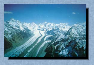
Western part of Kunlun mountain of China. There are in Kirghizstan some areas constitute interest for mountaineering activity. These are Central Tien-Shan, Kirghiz Range, Terskey Range, Turkestan Range, Zaalai Range, Alai Range, Western Kokshaaltoo Range, Akshirak and Kuilu Ranges.
Season:
the 20 of June - the 10 of September.
Members carry out ascents and choose tactic for the ascent them-selves. They have their own outfit which is necessary for ascent. Service. All transfers from Karakol to the base camp and back, accommodation in hotels, bases and base camp, route consultations, radio connection,full board, all formality. Service for extra payment: Arranging of transfer from Almaty or Bishkek to Karakol, helicopter flight from the Issyk - Kul lake to "Maida-Adyr", helicopter show-flight over the peaks, helicopter transfer to the beginning of a route, carrying by helicopter of load to the route, accompaniment by guides, helicopter flights to the lower camp for rest and other services. Size of the group is not limited |
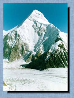
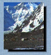
The usual tactics which is used on the classical route from South: - 6 km crossing of the South Inilchek glacier, ascending 200 m to " Shubin's stop " bivouac (4300 m); - along the narrow and steep Semenovski glacier you should ascend to the upper mould and at the altitude of 5800 m under the west column pitch camp 1. After 2 nights and 6200-6500 m ascent you should descend to the base camp. After the rest day are 1-2 days of ascent to the camp 1 with the new baggage for high altitude camps. It is necessary to start early in the morning in order to avoid avalanches that are more probable in the middle of day; - reach the altitude of 6300-6400 m and pitch camp 2; - ascend 300 m and pitch camp 3 under the summit at the altitude of 6700 m; - during the day you should reach the summit and descend to the camp 3. The way from the seds goes on rocks with good ledges and on snow and ice fields. It is recommendate to hang up the fixed roups on the most dangerous places (about 280 m); - descend to the camp 2 and then to the camp 1; - descend to the base
camp.
- approach (15 km) the northern wall from the base camp "Inylchek" along the Zvjozdochka glacier; - ascend along the icefall to the Diky pass (5200 m); - ascend along the northern edge of West Pobeda (6918 m);- traverse of the western crest 4 km at the altitude 7000 m; - descend back. The program can be changed by the "ITMC Tien-Shan" if the group wishes. The ascent tactics can vary according to the experience of members and conditions of the ascent. |
|
New version of our pages here: www.dd.volga.ru/itmc/ |